
News | Events
We are out there !
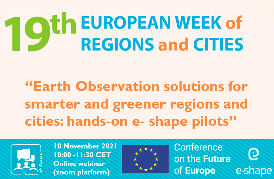
e-shape side event at 19th European Week of Regions and Cities
Hits: 3350
Earth Observation solutions for smarter and greener regions and cities: hands-on e- shape pilots
10 November 2021 10:00-11h30 cet
Online webinar (zoom platform)
Background
Despite the many successful examples of use of satellite-based services at the regional and local levels, they are still widely considered as “innovation” rather than “practice”.
This workshop will present and discuss solutions to use satellite data and signals, which can make a real difference for public managers and civil society willing to increase sustainability and resilience to climate change and critical events.
The workshop aims at bringing together representatives of regional/local administrations, SMEs, research centres to discuss about the opportunities and challenges to the operational uptake of mature satellite-based services.
The solutions to be presented have been recently developed to improve services that already existed or to respond to emerging city challenges, such as climate change and the COVID-19 sanitarian crisis.
In this context, the pilot projects developed within e-shape represent concrete examples to that effect, as they have been conceived with the vision of an “umbrella” of services helping authorities, but also enabling a commercial application in the green sector.
The workshop
The workshop is an e-shape labelled event, the European Commission’s Horizon2020 flagship project supporting the EuroGEO initiative demonstrating European EO capabilities applied to 7 showcases, including climate change, energy, ecosystems co developed with and for the users. The project’s ultimate goals is to foster entrepreneurship and develop research to business activities.
The first part of the workshop will set the stage by introducing the audience to operational satellite applications, their uses and their benefits for regions and cities, with a particular focus on the issue of green energies, climate change mitigation and sustainable development and growth.
The second part of the workshop is devoted to the presentation of the coordinated approach to support research communities bringing their satellite-based solutions to serve policy makers and boosting innovation in the field of Sustainable Development Goals and environmental policies.
The format foresees a Q&A and the end of the first part of the workshop and a discussion/Q&A/breakout-rooms at the end of the dual presentations to boost interaction and live engagement between the audience and the pilots through feedback useful to inject in the co-design methodology of the service development.
For more click here
Draft agenda
10.00 - 10.05 Annalisa Donati, Acting Secretary General EURISY- Welcome and Introductory remarks
10.05 - 10.10 Douglas Cripe, Senior Scientific Adviser, GEO Secretariat
10.10 - 10.20 Bente Lilja Bye, CEO BLB and Norway representative of GEO Programme Board
10.20 - 10.35 Aida Campos, senior researcher at IPMA, the Portuguese Institute for Sea and Atmosphere, “Monitoring Fishing Activity”
10.35 - 10.45 Grégoire Jauvion, Data sciences Lead, Plume Labs
10.45 - 11.00 Jana Klanova, prof. RNDr., Ph.D. Head, Human Exposome Masaryc University, “EO-based surveillance of POPs pollution”
11.00 - 11.30 Round table with speakers
11.30 Wrap-up and closing remarks
e-shape, is a 48-month project under the framework of Horizon 2020 and constituted by a pan-European team of academic, industrial, institutional and user communities. It is a unique initiative that brings together decades of public investment in Earth Observation and in cloud capabilities into services for the decision-makers, the citizens, the industry, and the researchers. It allows Europe to position itself as a global force in Earth observation through by leveraging Copernicus, making use of existing European capacities, and improving user uptake of the data from GEO assets, opening new opportunities and expand its use, through the existing European capacities, as well as developing research to business activities.
Speakers
Annalisa Donati is currently Acting as secretary general of Eurisy, the European association of space agencies striving to bridge the gap between space and society. As Research Fellow at the European Space Policy Institute she was responsible for the studies on space economy, finance and innovation’s domains. Before joining ESPI she was a Young Graduate Trainee within the Industrial Policy and SMEs Division of the European Space Agency (ESA) and Temporary Officer at the United Nations Office for Outer Space Affairs (UNOOSA). Annalisa holds a M.S. in Diplomatic Studies from the SIOI and in Multilateral Security from the University of Perugia.
Francesca Piatto is project officer at EARSC, the European Association of Remote Sensing Companies, which coordinates and promotes activities of European companies engaged in delivering EO geo-information services. She is currently the e-shape project WP coordinator, a European project that develops and promotes European Earth Observation capabilities with and for the users. Prior to this role, she collaborated with the Italian Chamber of Commerce in Rosario (Argentina) assisting with EU projects, and Business Bridge Europe, where she worked for the annual EU Space Conference. Francesca holds a MA in EU external relations and international migration from the University of Kent’s Brussels School of International Studies.
Aida Campos is a senior researcher at IPMA, the Portuguese Institute for Sea and Atmosphere, and a member of CCMAR, the Centre of Marine Sciences of the University of Algarve. She is a national representative to DG RTD Strategic Working Group SCAR-Fish, which she presently chairs. She has more than 30 years of experience in the areas of fisheries technology, gear selectivity and management of by-catch and discards, and she is now mainly involved in the analysis of fisheries dynamics and estimation of fleet-based fishing effort.
Jana Klanova, is Professor of Environmental Chemistry at Masaryk University and Director of RECETOX, the European Centre of Excellence in Environmental Health Sciences.She has vast research experience in the field of environmental and health the impacts of toxic substances on external and internal environments, products, and food. Through collaboration with the United Nations Environment Programme and World Health Organization, she supports development of global monitoring networks and information systems enhancing availability of data for environment and health policy and practice. She leads the GEO (Group of Earth Observations) Initiative GOS4POPs (Global Observation System for Persistent Organic Pollutants) and coordinates an effort to build a sustainable infrastructure for European exposome research.
Douglas Cripe is an expert on climate, water, oceans, and science and technology, and is currently serving as Work Programme Coodinator at the intergovernmental Group on Earth Observations (GEO) Secretariat, in Geneva. He received his PhD in Physical Geography (climatology) from Kent State University and MSc in Atmospheric Science from Colorado State University. Before joining the GEO, Dr. Cripe was a Senior Scientist at the Institute for Environmental Sciences (ISE) at the University of Geneva; has served as assistant editor for the Environmental Science & Policy Journal (Elsevier); served as the coordinator for the climate module of the Environmental Diplomacy course offered jointly with UNEP and the Graduate Institute of Geneva; and worked several years as a Research Associate in climate modeling at Colorado State University.
Bente Lilja Bye has been a member of the GEO community since 2004, engaged both as representative in the GEO plenary, in committees and contributing to the GEO Work Programme, and currently represents Norway on the GEO Programme Board. Bente runs a small research and consultancy company, BLB, focusing on transforming Earth observation data to information and knowledge for societal benefit. She is responsible for Communication, Dissemination and Assessment as partner in NextGEOSSRoles and activities in NextGEOSS: Communication, dissemination, sustainability, Cold Region Pilot. Citizen Science, business pilots.
Roya Ayazi, Since 2009 Secretary General of NEREUS (Network of European Regions Using Space Technologies) heads its Brussels/Belgium based secretariat and is the main interface of the association at European level. She followed the major space legislative procedures with impact for the downstream sector in the past 10 years and established the network as a reference for regional user-communities. Roya’s core responsibilities comprise advocacy and political interest representation towards the European institutions and the European Space Agency, international networking and collaborations as well as the overall coordination of the network activities such as EC/ESA-funded projects and key political events. Driving the Copernicus4regions initiative to make regional user-experiences more transparent and stimulate interregional knowledge sharing and collaborations, Roya is always in close contact with regional stakeholder and different user-communities.
Being trained as a German lawyer, Roya Ayazi held for more than 20 years positions in European/Governmental Affairs and has work experience in public administration and associations of civil society represented in Brussels.
About the organisers


Acknowledgment
The e-shape project has received funding from the European Union’s Horizon 2020 research and innovation programme under grant agreement 820852